|
| Firetide's live VGA resolution video feeds are provided to the public via the Internet |
Firetide, Inc., the leading provider of high-performance wireless infrastructure mesh networks, recently announced that Thailand’s Royal Irrigation Department has completed its phase three deployment of the world’s first mesh network capable of delivering live high-definition (HD) wireless video feeds of river water levels and telemetry data for real-time flood forecasting and historical data collection. In addition to the live HD video feeds to the control room, live VGA resolution video feeds are provided to the public via the Internet. The Firetide network, which covers a geographical distance of 372 km (231 miles), is the world’s longest fully redundant wireless mesh network. New expansion phases of the network are planned for deployment beginning in 2H of 2012.
Each year the reigning King of Thailand, Bhumibol Adulyadej, takes a journey up the Chao Phraya River to get a better understanding of the well-being of the Thai people and to get a first-hand look at the river and the massive agricultural fields it feeds. Now at the age of 84, the King is unable to take this annual trip up the river, but still wishes to monitor rising water levels during the monsoon season in order to provide the Thai people with an early flood warning system and to keep a close eye on the health of the country’s agricultural crops along the river.
To acknowledge the King’s birthday wishes to protect the country’s citizens and agricultural crops during the annual monsoon floods, the Thailand government decided to deploy a video and data network that enables citizens, security, and agricultural officials to monitor 372 km of the flood prone Chao Phraya River basin. After a full year of extensively testing different ADSL, satellite, GSM/3G and wireless technologies for this massive video and data network, the Thailand Royal Irrigation Department deployed Firetide’s high-bandwidth wireless network to provide reliable live HD video feeds and mission-critical water level data applications 24/7.
“The cost of deploying this huge public safety network over a distance of 372 km would not have been feasible using traditional wired or fibre technology,” said Mr. Chachawal Punyavateenun, project creator and deputy director general of Thailand Royal Irrigation. “Point-to-point and point-to-multipoint wireless technologies were tested but were not able to overcome the technical requirements of this challenging network.
Furthermore, the speed in which the project team could deploy a fully redundant wireless infrastructure consisting of over 25 wireless links (hops) could have only been accomplished with Firetide’s intelligent multipoint-to-multipoint wireless mesh architecture.”
Firetide’s wireless infrastructure mesh network provides the people of Thailand with an advance flood warning system to mitigate property damage and saves lives. During the 2011 monsoon season, Thailand’s Chao Phraya River basin experienced the worst flooding in more than half a century. The flood waters inundated nearly 240 thousand square km of land with average depths of 1.8 to 3 meters. More than 12.8 million people across 58 Thai provinces were affected by the flood, and the death toll from July through October rose to more than 600. The flood of 2011 was the world’s fourth costliest natural disaster with estimated damages exceeding 45 billion USD.
Throughout this monsoon flood of 2011, the Firetide wireless network captured live video of rising river levels and made the images accessible to the Thai people via a real-time web feed. Nearly 300,000 daily web hits provided live images and information of the entire flood situation to the citizens and public safety officials of Thailand. The web feed proved to be a huge success and played an important role in providing citizens with real-time information needed to make critical decisions for moving valuable property in time to avoid the flood waters. Despite the flood’s massive devastation, the wireless network aided in saving countless lives and billions of dollars in property damage.
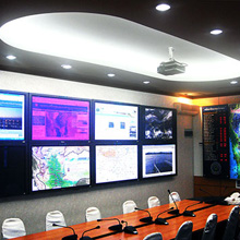 |
| Firetide's wireless mesh network provides an advance flood warning system to migrate property damage |
Besides video, the Firetide wireless network supports a supervisory control and data acquisition (SCADA) system that communicates and monitors the functionality and physical status of large water gates and dams that influence the amount of water being released downstream. The system also collects and monitors river water levels continuously and records the data for real-time analysis. The ability to collect live telemetry data provides authorities with the information needed to make immediate mission-critical decisions, as well as capture necessary data to plan for future floods.
The Deployment
Embes Technology, a Firetide premier-level system integration partner, was selected to design and deploy the Firetide wireless network. Embes Technology was instrumental in early conceptualisation, design and technology trials that proved beyond a doubt that Firetide’s infrastructure mesh is a viable and scalable technology that exceeded the requirements of this project. In addition, Embes Technology played a key role and was responsible for detailed site surveys, tower design and equipment installation. Embes began deploying the wireless network in 2010 and recently completed phase three.
The current Firetide wireless network consists of 64 Firetide HotPort 7020 wireless mesh nodes and 27 Panasonic PTZ WV-SW395E cameras. Deployment of the Firetide wireless video network was completed in less than one year, whereas a wired network would have required two to three years to complete. Furthermore, the flexible Firetide wireless network can be easily expanded for future uses and is much more cost effective compared to deploying a wired network. Firetide distribution partner CommExpress (Thailand) also played a key supporting role in the trial and deployment phases of the project.
“After thorough testing and planning we found the reliability, performance and value of the Firetide wireless solution to be a perfect fit for current and future growth of Thailand’s early flood warning system,” said Dr. Nat Marjang, project manager and faculty of engineering, Kasetsart University. “The project’s success is a testament to the dedication and years of collaboration between Thailand Royal Irrigation, Kasetsart University and the technology partners involved.”
A Unique Network
After two successful pilot deployments, the installation team completed the main deployment of Firetide mesh nodes along the Chao Phraya River. Each node links wirelessly to adjacent nodes upstream and downstream to form the mesh network. With link distances, or “hops,” of 20-45 km between nodes, the system delivers up to 240 Mbps bandwidth with less than a one millisecond delay per hop for smooth, real-time data and video delivery for the entire length of the network. The Firetide mesh network also provides full redundancy so if a link fails, another link takes over immediately with no noticeable interruption in service. The actual combined length of all links, including redundant links, deployed within the 372 km geographical distance totals 550 km or 341 miles, making the Firetide network the world’s largest and longest wireless mesh network.
“Firetide’s wireless infrastructure mesh technology plays an increasingly important role in helping governments and public safety agencies keep their citizens and property safe,” said Duane Zitzner, chief executive officer of Firetide. “Nowhere is this safety more critical than during major natural disasters that involve the lives of millions of people and potentially billions of dollars of property damage. Thailand has validated that our technology meets their most critical requirements and sets the standard for reliable, secure and rapidly-deployable large scale wireless video surveillance.”